Find the route for you

|

|

|

|

|

|

|

|

|

|

|

|
RANGE Local routes |
TYPE Circular |
LENGTH 10.3km |
SURFACE Mostly asphalt |
DIFFICULTY 1/5 |
POSITION south-east |
MARKS Local |
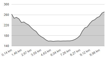
ELEVATION 140m |
LOWEST POINT 157m |
HIGHEST POINT 272m |
Marija Bistrica – Route 5
Vinski Vrh - Platužići - Tugonica - Habazini - Vinski Vrh

Route 5 starts in Vinski Vrh on the County Road Marija Bistrica – Konjšćina, where Route 2 passes as well. Route 5, however, immediately turns west, onto the local quiet narrow paved road towards Tugonica. For the first four kilometres, the Route follows a slight downhill incline, with the first half going through a forest, and the second through an area surrounded by low hills. In Tugonica, the route descends into the valley of the river Krapina and turns east along the lowlands by the river, by three beautiful small fish-ponds. The route passes through the valley, stretching by the river for 3.6 km. Since most of the section, namely 3.2 km, entails a dirt road, and there is 400 metres of gravel road, this route is suitable only for mountain bikers and only in dry weather. After reaching the local road, turn right and then right again. After a 2.5-kilometre ride through a quiet landscape and up a slight incline, you will find yourself back at the start.


