Find the route for you

|

|

|

|

|

|

|

|

|

|

|

|
RANGE Local routes |
TYPE Line |
LENGTH 5.7km |
SURFACE Mostly asphalt |
DIFFICULTY 2/5 |
POSITION north-west |
MARKS Local |
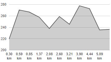
ELEVATION 170m |
LOWEST POINT 208m |
HIGHEST POINT 283m |
Klanjec – The St. Florijan Route
Klanjec - Sveti Florijan - Goljak Klanječki

Although only 6 kilometres long and marked only by small arrows with the symbol of the bicycle, the route Klanjec – Sveti Florijan – Goljak Klanječki is one of the most attractive routes in the County. It passes along a very picturesque hill ridge on narrow local roads with almost no motor traffic, partly through forests, and partly through meadows and vineyards. The numerous wayside crosses and two beautiful churches, the Church of St. Florian and the Church of St. Philip, give the route its special flair. A little more than 3 km of the route is on paved roads, and 2.6 km on a relatively good gravel road, suitable for trekking bikes. Despite the fact that there are no more signs after Goljak Klanječki, you can go down just as picturesque roads towards Kraljevec na Sutli or Radakovo in the valley of the Lučelnica stream.


